Overview
Oxford City Council will contribute to the improvement of walking and cycling routes in the city with the development of the Oxpens River Bridge.
The new pedestrian and cycle bridge will provide a new crossing of the Thames that will provide an attractive route for people from the west and south to and from the city centre.
It will serve as a vital link for local people, offering quick and safe walking and cycling routes, helping to reduce congestion in and around Oxford city centre.
A bridge is a requirement of the Oxford Local Plan to support the wider regeneration of the West End of the city.
Funding for the project comes from the Oxfordshire Growth Deal.
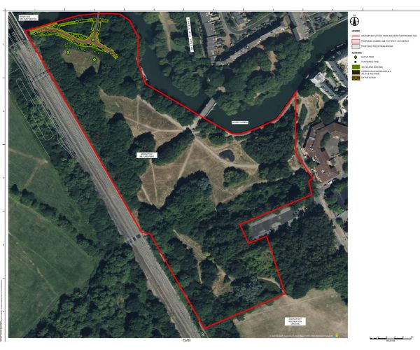
Location
Location map for Oxpens Bridge development in Google Maps
Project timeline
- A public consultation on initial designs took place in person and online in summer 2022.
- A full technical design has been developed and approved.
- Planning permission was issued on 8 July 2024 following the completion of a S106 agreement.
- Preparatory works for bridge work, including pollarding and removal of selected trees, was undertaken in February 2024 ahead of bird-nesting season. A commitment has been given to replant trees in the area to mitigate for the loss.
- Construction could not start in 2025 as the project was subject to a Judicial Review. The case was heard in the High Court in February 2025, and the case was dismissed.
- Permission to build across the River Thames was granted by the Secretary of State for Transport on 17 June 2025.
- Work is underway to prepare and submit information to satisfy the planning conditions, which were included as part of the consent granted in July 2024. This is a normal part of the planning process.
- During the detail design process, an opportunity was identified to adjust the alignment of the footpath on the south side of the river. A non-material amendment was submitted and approved in January 2026. This will allow for over 70 of the original trees to be retained.
- The council appointed Jacksons Civil Engineering in January 2026.
- Work is due to start in Summer 2026 and complete in Spring 2027.
- Following construction, the Council will replace and plant additional trees to maintain the area's level of tree canopy and biodiversity.
Latest News
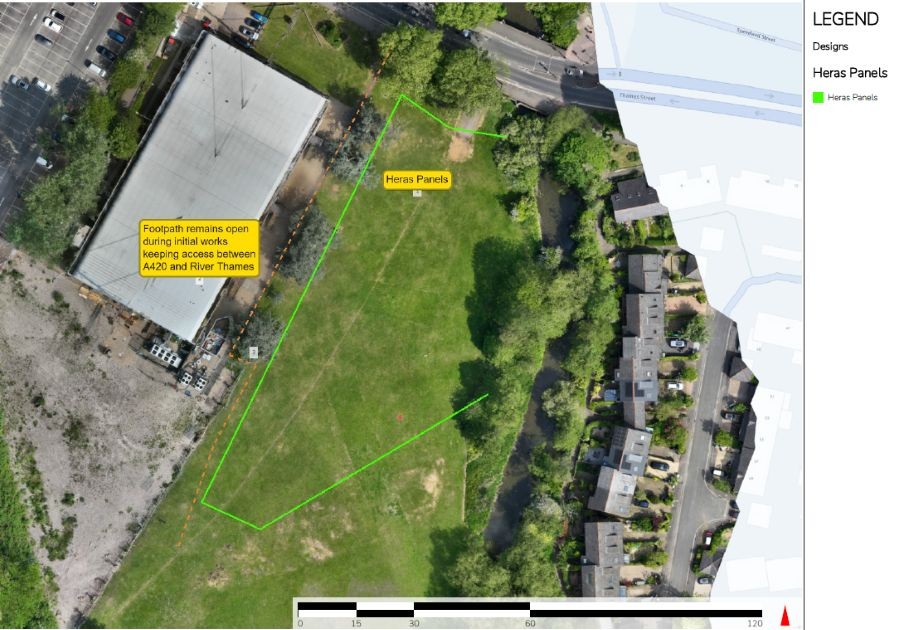
Jackson's Civil Engineering will carry out additional survey work at Oxpens Meadows and Grandpont Nature Park in connection with the new bridge in June 2026. The first phase of work will include construction of a site compound and access route. Topsoil will be removed where the hardstanding is created and stored for reuse when the works are complete.
Some trees will be removed at the start of the work. This will be supervised by an ecological clerk of works to ensure no removal of trees that are being used by nesting birds. The retained trees will be protected during the works, and public footpaths will be open during the initial enabling works.
It will be necessary to close footpaths later in programme of works and diversion will be signed when this is necessary. The footpath along the Castlemill Stream will remain open and will be unaffected by the work.
Details of the area to be fenced for the enabling works is shown indicatively below:
If you have any questions please contact regeneration@oxford.gov.uk
Frequently Asked Questions
Why is a new bridge needed here?
A series of regeneration projects are planned to regenerate the West End of Oxford and increase the number of residents, workers and visitors in the area.
This includes the redevelopment of Oxford Train Station, Oxpens and Osney Mead Industrial Estate.
With more people using the area, and to minimise congestion at existing routes in and out of the area, the Oxford Local Plan and West End Area SPD (Supplementary Planning Document) identified the need for better connections between areas, particularly east to west over the Thames.
The proposed new bridge, designed for pedestrians and cyclists, will provide a direct, convenient and visually pleasing connection between the two growth areas at Osney Mead and Oxpens and an off-road pedestrian and cycle route to the City Centre from the South.
Gasworks Rail Bridge and Gasworks Pipe Bridge
There are two existing bridges across the Thames in the area, the Gasworks Rail Bridge and the Gasworks Pipe Bridge.
The Gasworks Pipe Bridge is being repaired under a separate project; this is expected to be completed and the bridge re-opened in 2024.
The use of the Gasworks Rail Bridge to improve connections in the West End has been considered. A report was commissioned by Oxfordshire County Council and issued in 2017. The County Council did not pursue the options in the report and has confirmed that the report was prepared before the development proposals in Oxford’s West End were incorporated in the Local Plan and that the report is high level in nature, does not necessarily reflect the County Council’s views and it could be anticipated that the proposals could have significant planning and flooding challenges and that the proposals do not reflect latest design standards.
In the light of concerns that have been raised more recently an informal review of the options was undertaken and concluded that the options identified in the report would not reach current recommended standards for cycling, do not take into account increased flood risk, the impact on the adjacent properties or Oxpens Meadow, or deliver the potential capacity of the proposed bridge. The Gasworks Rail Bridge is maintained by Oxford City Council and will remain available to use.
Conflict between pedestrians and cyclists
A three-and-a-half metre-wide unsegregated shared-use bridge and unsegregated shared-use connecting paths are proposed. This will provide sufficient width to reduce the potential for conflict between cyclist and pedestrians. The provision meets current standards and guidance on new cycle provision.
The bridge is likely to attract a wide range of users, including commuters, dog walkers, families and visitors to the city, all wanting to explore or view the area from both sides of the bridge width.
Potential conflict between pedestrians and cyclists using the bridge was discussed during the public consultation.
Segregating the bridge into separate lanes for pedestrians and cyclists would result in the need for a wider bridge that would be more visually intrusive, more impactful on the ecology of the site and involve more materials and associated carbon. It would also be difficult to enforce the segregation and could result in cyclists failing to slow down as they travel over the bridge.
The legal status of even a segregated footway and cycleway is that pedestrians can use both sides. We want to avoid the potential perception that cyclists have right of way, which may increase cycle speeds and give the impression to pedestrians that the cycleway is an area not permitted for their use.
A “shared” provision is likely to provide a more flexible space in terms of self-enforcement of appropriate speeds at busy times, i.e., people walking across the full width of the bridge may help prevent cyclists from dominating the space.
Lighting
The decision has been made not to light the bridge at this time. However, the bridge design will provide the option for the lighting to be ‘retrofitted’ in the future should it be needed.
Consultation responses were divided and inconclusive about the provision of lighting.
Concerns were raised about partially lighting routes to, and from, the bridge, causing difficulties for people moving between lit and unlit areas. Lighting the bridge and connecting paths would improve the sense of safety of people using the bridge, particularly during the winter months.
This is a sensitive ecological area along the Thames and Grandpont Nature Reserve, so any future lighting will have to be carefully designed to minimise disruption to the habitats of animals, including bats.
Impact on Grandpont Nature Park
The proposed bridge lands at Grandpont Nature Park, close to the level of the higher path at the western end of the park. The existing towpath will remain unaltered alongside the river.
The proposals include the improvement of the existing path between the proposed bridge and the railway bridge to the west. The path will be 3.5 metres in width and the gradient reduced to make it easier for pedestrians and cyclists to use and reduce the potential for conflict.
The park will remain a natural area accessible to local people and no changes to the overall design and management of the park are proposed.
Ecology and Trees
Impacts on habitat and species in the area have been considered during the development of the bridge design to minimise disruption to species and habitats, including the river.
To ensure the proposals achieve a Biodiversity Net Gain the government's Metric has been used to assess the current condition of the site and identify how a net gain will be achieved through the development. Details were submitted with the planning application for the bridge and include;
- The location of the bridge has been sited away from the area of Grandpont that has the best-quality habitats and trees
- Tree planting with appropriate native species to maintain the tree canopy in the area
- Additional understorey planting to increase diversity of habitat
- Installation of bird and bat boxes
- District Newt License to enhance newt habitat
This will be met through additional tree and understory planting within Grandpont Nature Park and the wider area.
Some pollarding and tree removal took place in February 2024. The removal of the trees did not require permission and was undertaken to avoid disturbance to birds during the nesting season.
The construction of the bridge and work to the path will require some further tree removal. These works will be undertaken in accordance with the Ecological Assessment accompanying the planning application.
In the event that tree removal is required during the bird breeding season, a search for nesting birds will be undertaken by a suitably qualified ecologist immediately prior to the felling of the trees to confirm the absence of nesting birds. If nesting birds are discovered, felling of the tree will need to be delayed until nesting activity has been completed and the nest vacated.
During the construction works, appropriate working practices will be in place to avoid harm to protected species, including breeding birds, with works carried out under a district licence about the potential presence of great crested newts.
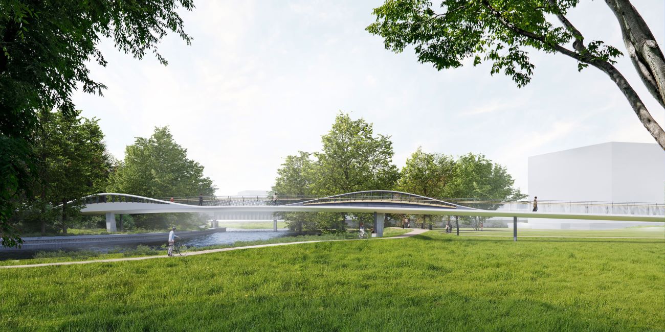
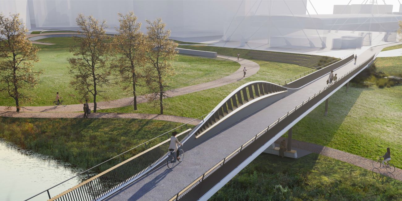
Bridge Design
Due to the sensitive nature of the site bridge, Knight Architects were appointed to design a bridge appropriate to the setting. The architects explored the siting options and considered that the bridge structure should be visually lightweight where it crosses the river and the meadow, to maintain views and land where it minimised the impact.
The resulting bridge design is a carefully considered response to the site, both in terms of aesthetics, local character and engineering.
The length of the bridge span puts additional requirements on the bridge structure, meaning a timber construction would not be feasible. Timber also has increased maintenance requirements.
The span of the bridge ensures the Thames path is not impacted by support structures, and on the north side, access is raised to provide a dry route at times of flood.
The approaches to the bridge are designed to meet accessibility requirements, avoiding steep slopes and ensuring the bridge connects to the right places on the best available lines.
The proposed approach seeks to minimise impacts on views by locating the supporting structure away from the point where the bridge crosses the river Thames and the meadow.
The supporting structure takes the form of two waves which will also frame views and create a sense of rhythm when passing over the bridge.
Where the bridge crosses the meadows, the design aims to balance the number and size of the supporting columns to ensure the bridge appears as lightweight as possible.
Maintenance
Upon completion of the bridge, the structure will become the responsibility of Oxfordshire County Council for upkeep and maintenance. The design of the bridge has been deliberately considered to support the ease of maintenance. The bridge width and height are sufficiently open to reduce the likelihood of people congregating underneath it. The materials, including steel, are easy to clean.
Funding
Funding has been secured from the Oxfordshire Growth Deal Funding, for which the County Council is the accountable body. This funding was awarded by the government to support the delivery of housing, a planned part of the West End redevelopment. The City Council cannot use the funding for alternative projects, as this would breach the funding agreement with the County Council.
Path improvements connecting to the bridge are to be funded by Housing Infrastructure Funding (HIF). This funding was secured by the City Council to support the delivery of infrastructure to support housing growth.
Should there have been an Environmental Impact Assessment of the proposed bridge?
Environmental Impact Assessment is not required for all planning applications. The requirements for EIA are set out in the T&CP (Environmental Impact Assessment) Regulations as amended. The planning application was screened by the planning authority and was not identified as requiring EIA. However this does not mean that the impacts of the bridge were not assessed. The planning application for the bridge is accompanied by an Environmental Risk Assessment, Ecological Assessment, Arboricultural Impact Assessment. Bio Diversity Net Gain Report and metric, Archaeological Note, Flood Risk Assessment and Surface Water Drainage Strategy and Ground Investigation Report.
Has flooding in the area been considered?
The planning application was accompanied by a Flood Risk Assessment and Surface Water Drainage Strategy that looked at the flood implications of the proposal. This was reviewed by the Environment Agency as part of the planning process and they raised no objections to the proposal in relation to flood risk
How long will the work take?
We anticipate that the bridge will be complete in March 2027.
Additional works are being planned for the Meadow as part of the Oxpens development. It is hoped that these works will follow the bridge works to prevent closing the meadows twice but this will not be known until early 2027. Once the works are complete the Meadow will be restored with new wetland swale and planting to support biodiversity.
Will footpaths be shut?
Initially footpaths will remain open but the footpath along the River Thames will be shut when works are taking place nearby and diversions will be in place. The footpath along Castlemill Stream to the Gas Works Rail Bridge will remain open.
Will the works affect the Ice Rink?
The ice rink will remain open during the works.