Contents
- Introduction
- The asset base
- Planning advice and fieldwork statistics
- Outcomes from previous planning advice
- An overview of the patterns of archaeological fieldwork in 2024
- Public engagement
- Developing the archaeological research agenda
- Other available monitoring data on the historic environment
Executive summary
The following report provides an overview of the impact of development on archaeological assets in the Oxford Local Authority Area in 2024. The year saw a number of infill housing developments, college developments and renewable energy schemes that had a small cumulative impact on significant assets and revealed significant new information the city and its hinterland.
A significant discovery was made at Oriel College where the identification of a large Late-Saxon ditch by means of an archaeological borehole transect confirmed line of the initial (primary) late-Saxon eastern defences of the town after over 100 years of speculation, the broad alignment first being postulated in 1899.
The year was also notable for producing new insights into the layout of Oseney Abbey at Gibbs Crecent, the Kings Houses (the Norman palace north of the town known as Beaumont Palace) and the distinctive spine of tenements located along Catte Street and Parks Road that attracted artisan trades associated with the University in the medieval period.
Elsewhere in the hinterland of Oxford a new area of early Saxon settlement was discovered at the Dominion Oils site in Littlemore. To the north of the city enclosures associated with Roman rural settlement, partly visible as parch marks from the air in University Parks, were investigated at Norham Gardens.
1. Introduction
The National Planning Policy Framework requires that local planning authorities should make information about the significance of the historic environment, gathered as part the development management process, publicly accessible. The Oxford Archaeological Plan (2018) established the objective of producing an annual monitoring statement for archaeological heritage assets and this is the eleventh such report. The aim being to capture data about the patterns of development impacts across the years and also monitor the effectiveness of heritage management processes.
The following report provides a short overview of the scope and impact of development led archaeology in Oxford in 2024. It records the number of planning applications submitted over the calendar year and the number assessed to have likely archaeological implications. It records the types of archaeological fieldwork undertaken and summarises how development and archaeological mitigation have impacted on known archaeological heritage assets. Furthermore, it relates the year’s archaeological discoveries to an evolving research agenda to show how our knowledge and understanding of Oxford and its people is developing and expanding over time. The annual statement also provides a basis for monitoring the on-going cumulative impact of both development and asset management on the city’s archaeological resource.
2. The asset base
The designated assets within the Oxford City local authority area comprise:
- Over 1,500 listed buildings (this number relates to the number of buildings rather than designations as these can encompass multiple buildings. At the end of 2024 the National Heritage List recorded 1186 listed building designations for Oxford.
- 12% grade I listed buildings (the national average is 2%)
- 8% grade II* listed buildings (the national average is 4%)
- 18 Conservation Areas - representing 20% of the city area
- 10 Scheduled Ancient Monuments (NB The National Heritage List now records ten monuments rather than the previously stated 12 because the Bridge West of Godstow Abbey (County No 173) and the extension to Port Meadow (County No 120003) are amalgamated with Godstow Abbey (County Number 35542) and Port Meadow (County Number 143) respectively.
- 15 Registered Parks and Gardens
In addition to these designated assets further archaeological monuments are recorded on archaeological databases covering the city. The monument database includes extant and documented monuments (i.e. those which may no longer survive).
At present two complementary archaeological data sets are maintained for Oxford: The Urban Archaeological Database (UAD) which covers the historic core of Oxford and the Oxford Historic Environment Record (HER) which covers the area outside the UAD. These two sets of data are both now maintained by the City Council and have been recently combined into the City of Oxford Urban Historic Environment Record (COUHER).
The combined monument database (which includes a number of duplicate records that need revision) totals 3468 records (Oxford District Search). This number has increased over the year due to work undertaken on the transfer of records from the National Record for the Historic Environment onto the Oxford HER.
3. Planning advice and fieldwork statistics
The information and tables below provide data about the number of applications assessed and commented on by the City Council Archaeologist and the number of archaeological recording events undertaken by archaeological contractors in Oxford in 2024. Additional data is provided on the number of Scheduled Monument Consent notices issued by Historic England over the course of the year.
Planning applications to Oxford City Council
Number of applications assessed for heritage interest (excluding renewals and amended schemes, including full, outline, pre-applications, major applications, listed building applications, previous year data provided for comparison)
- 2023 - 1,386
- 2024 - 1,416
Number of applications with archaeological implications in 2024
- 2023 - 40
- 2024 - 53
Number of applications with archaeological implications as a % of planning applications
- 2023 - 2.8%
- 2024 - 3.7%
| Fieldwork type | 2024 |
|---|---|
| Evaluation trenching | 8 |
| Trial trenching (keyhole investigation secured through a planning condition, usually because of pre-existing site constraints) | 5 |
| Archaeological excavations | 8 |
| Archaeological watching briefs (observation of ground works by a qualified archaeologist) | 25 |
| Historic building recording | 10 |
| Geophysical survey | 2 |
| Salvage record (reactive recording of an asset either because of non-compliance with a condition or because activity is outside planning control) | 0 |
| Impact type | 2024 |
|---|---|
| Number of cases requiring Scheduled Monument Consent | 1 |
| Number of Scheduled Monument consents for complete or partial loss of fabric or character requiring mitigation of damage tbc | 0 |
| Number of Scheduled Monument consents for minor works without significant implications tbc | 0 |
| Number of Scheduled Monument consents for repair and restoration of monuments tbc | 1 |
4. Outcomes from previous planning advice
The tables below provide data on the outcomes of development on archaeological assets and an assessment of impact based on definitions provided by the National Planning Policy Framework.
| Monitoring outcome | 2024 |
|---|---|
| Number of significant breaches of planning condition or damage cases recorded over the year | 1 |
| Non-compliance with an archaeological condition with unknown impact on asset/s | 1 |
| Non-compliance with archaeological condition with subsequent mitigation undertaken | 1 |
| Number of appeals allowed where archaeological policies are cited as a reason for refusal | 0 |
| Number of developments in 2022 within the City Centre Archaeological Area (defined in the Local Plan) that required a full excavation more than 25m2 | 4 |
| Number of developments in 2022 outside the City Centre Archaeological Area (defined in the Local Plan) that required an excavation more than 100m2 | 0 |
| Number of major archaeological excavations awaiting publication more than two years after the completion of fieldwork | 23 |
| Number of fieldwork events that did not encounter archaeologically significant assets (these may include sites where archaeological monitoring has been required to ensure that consented development does not impact on significant remains) | 12 |
| Number of cases in City Centre Archaeological Area (defined in the Local Plan) where design was agreed, or design changes made, to avoid or achieve significant reduction in harm to or achieve significant preservation in situ of archaeological assets | 2 |
| Number of cases outside City Centre Archaeological Area (defined in the Local Plan) where design was agreed, or design changes made, to avoid or achieve significant reduction in harm/significant preservation in situ to archaeological assets | 0 |
Summary of archaeological assets impacted by development in 2024
Dominion Oils Site
Asset type: Early Saxon Settlement
- Loss of asset with mitigation
Notes: Former Dominion Oils site, Railway Lane, Littlemore. Full excavation of two early Saxon Sunken featured buildings, representing previously unknown settlement site.
Hertford College Library
Asset type: Medieval tenements
- Substantial loss with mitigation
Notes: First phase of substantial new basement excavation impacting on the rear plots of former academic halls and stone built medieval tenements fronting onto Catte Street associated with the development of the medieval book trade
Nos 17 and 19 Norham Gardens
Asset type: Roman settlement
- Less than substantial loss of asset with mitigation
Notes: Roman enclosures excavated north of University Park.
Gibbs Crescent, Osney
Asset type: Medieval Abbey
- Less than substantial loss of asset with mitigation
Notes: Walls, channels and surfaces belonging to Osney Abbey revealing further information about layout, sequencing and material culture.
Oriel College Kitchen, Magpie Lane
Asset type: Late Saxon defences, medieval college.
- Less than substantial loss of asset with mitigation
Notes: Primary Late Saxon defences identified by borehole transect and also remains from medieval college kitchen.
Trinity College Ground Source Heat Pumps
Asset type: Medieval tenements
- Less than substantial loss of asset with mitigation
Notes: Medieval tenement activity and post medieval college waste pits.
Pusey Lane
Asset type: Prehistoric features and medieval Palace and/or Friary remains
- Less than substantial loss of asset with mitigation
Notes: Prehistoric ritual and funerary monuments, medieval Royal palace and friary remains.
No 2 Nos 21 to 24 Pembroke Street, Staircases Nos 12 to 15, Pembroke College
Asset type: Late Saxon settlement
- Further characterisation of asset with limited intervention
Notes: Evidence for Late Saxon domestic activity on Pembroke Street.
The Chequers, 17A Beaumont Road, Headington Quarry
Asset type: Victorian Pub
- Further characterisation of asset with limited intervention
Notes: (Historic building recording of 19th c pub prior to conversion for domestic use.
Nos 116-117 High Street
Asset type: Listed Victorian building
- Further characterisation of asset with limited intervention
Notes: Historic building recording of features within 19th century building.
Nos. 9, 10‐11, and 12 High Street
Asset type: Late Saxon settlement
- Further characterisation of asset with limited intervention
Notes: Multiple features below the basement floor belonging to Late Saxon and medieval buildings that once fronted onto the medieval market.
Northfield Hostel, Sandy Lane, Littlemore
Asset type: Roman settlement
- Further characterisation of asset with limited intervention
Notes: Limited number of Roman features further defining Roman settlement area.
Staircases 1, 2, 3 and Wardens’ Lodgings, Wadham College
Asset type: 17th century Warden’s Lodgings
- Further characterisation of asset with limited intervention
Notes: Further recording of 17th century college building.
The Waynefleet Building, Magdalen College, St Clement’s
Asset type: Medieval and Post medieval tenements
- Further characterisation of asset with limited intervention
Notes: Medieval and post-medieval remains were recorded.
5. An overview of the patterns of archaeological fieldwork in 2024
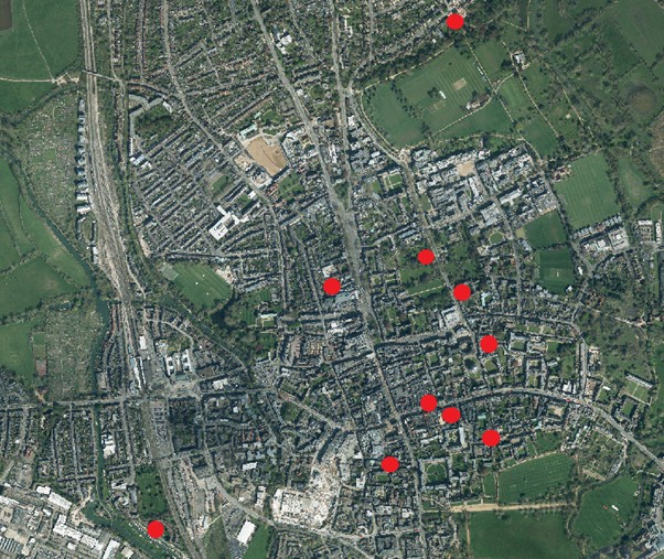
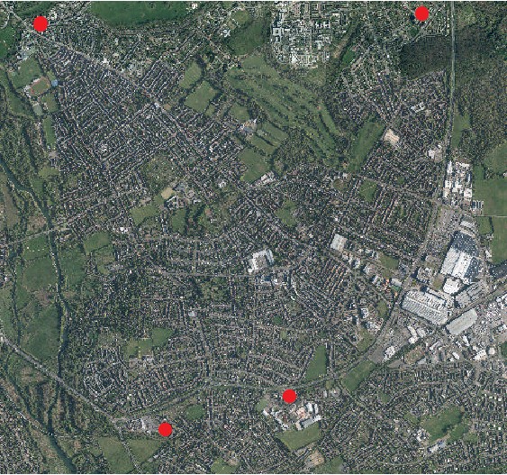
The sites assessed above are mapped below in order to show the broad pattern of investigation.
Current archaeological planning policy and the preservation of archaeological remains
The Oxford Local Plan Policy DH4 is reproduced below, it introduces a new emphasis on assessment of cumulative impacts on specific heritage asset types and community involvement (where feasible).
Within the City Centre Archaeological Area, on allocated sites where identified, or elsewhere where archaeological deposits and features are suspected to be present (including upstanding remains), applications should include sufficient information to define the character, significance and extent of such deposits so far as reasonably practical. This information should generally include:
- a Heritage Assessment that includes a description of the impacted archaeological deposit or feature (including where relevant its setting), an assessment of its significance and the impact of the proposed development on its significance, in all cases using a proportionate level of detail that is sufficient to understand the potential impact of the proposal. The Statement should reference appropriate records (including the information held on the Oxford Historic Environment Record); and
- If appropriate, a full archaeological desk-based assessment and the results of evaluation by fieldwork (produced by an appropriately qualified contractor. Pre- application discussion is encouraged to establish requirements). In the City Centre Archaeological Area where significant archaeological asset types can be shown to be subject to cumulative impact from development, the desk-based assessment should contain appropriate contextual assessment of this impact.
Development proposals that affect archaeological features and deposits will be supported where they are designed to enhance or to better reveal the significance of the asset and will help secure a sustainable future for it.
Proposals which would or may affect archaeological remains or features which are designated as heritage assets will be considered against the policy approach as set out in policy DH3 above.
Archaeological remains or features which are equivalent in terms of their significance as to a scheduled monument are given the same policy protection as designated heritage assets. Proposals which affect the significance of such assets will be considered against the policy test for designated heritage assets set out in policy DH4 above.
Subject to the above, proposals that will lead to harm to the significance of non-designed archaeological remains or features will be resisted unless a clear and convincing justification through public benefit can be demonstrated to outweigh that harm, having regard to the significance of the remains or feature and the extent of harm.
Where harm to an archaeological asset has been convincingly justified and is unavoidable, mitigation should be agreed with Oxford City Council and should be proportionate to the significance of the asset and impact. The aim of mitigation should be where possible to preserve archaeological remains in situ, to promote public enjoyment of heritage and to record and advance knowledge. Appropriate provision should be made for investigation, recording, analysis, publication, archive deposition and community involvement.
Overview of 2024
The year saw the continuation of a major housing project at Gibbs Crescent, involving the rebuilding of blocks of flats, located at the southern end of the site of Osney Abbey. Fortuitously a last-minute redesign of the foul sewer infrastructure meant that the impact on the southern precinct of the abbey was significantly reduced.
There were also a number of small infill housing and college developments in the hinterland of the city at the Dominion Oils site, Northfield House and Norham Gardens which impacted minimally on early Saxon and Roman rural settlement sites.
Within the historic core Oriel College renewed its kitchen, a process undertaken by several colleges over the past 20 years. The approach involved piling but also some surface works that impacted on parts of the now demolished east wing of the medieval college.
A significant discovery was made at the Oriel College site where the identification of a large Late-Saxon ditch by means of an archaeological borehole transect confirmed line of the initial late-Saxon eastern defences of the town, after over 100 years of speculation. The broad alignment first postulated in 1899 after an excavation in the Clarendon Quadrangle and never subsequently proven.
At Pusey Lane the rebuild of a St John’s College residential block involved new foundation that impacted on planting schemes and waste pits associated with the Norman Royal Palace and later Carmelite Friary. The Pusey Lane site also recorded a number of features that were potentially part of potentially significant prehistoric funerary or ritual monuments. We await the results of the scientific dating samples taken by the Oxford University Research Laboratory.
The year was also notable for producing new insights into the distinctive spine of tenements located along Catte Street and Parks Road that attracted artisan trades associated with the University in the medieval period.
At Trinity College a new ground source heat pump array involved the excavation of medieval tenement and post-medieval college remains within a narrow link trench for the dispersed GSHP array, demonstrating the impact that such projects can have in sensitive locations.
To the south along the same axis a major excavation in the main Quadrangle of Hertford College began to reveal medieval remains from medieval tenements associated with academic halls and medieval book trade fronting onto New College Lane and Catte Street, more results will follow in 2025.
The developments at Oriel College, St John’s College (Pusey Lane), Trinity College and Hertford College can be assessed as having significant cumulative impacts on important assets (the Royal Palace, tenements associated with artisan production, medieval Oriel College kitchen) continuing the established trend of college developments putting pressure on, and causing cumulative loss to, important archaeological assets within the Historic Core.
However, of these projects only the Hertford site involved a substantial impact on buried assets because it involved basement construction (the project continued into 2025). The others involved piling, limited strip foundations or surface trench construction that had a more restricted and localised impact.
6. Public engagement with archaeological heritage
The Oxford Archaeological Action Plan 2013-2018 sets out the aspiration of the Urban Design and Heritage Team to maintain a programme of public outreach including talks, walks and media engagement. Below a selection of archaeological outreach work in 2024 are highlighted:
- The archaeology and history of Oxford’s commercial core was featured on the hoardings for the phase 1 Clarendon Centre redevelopment on Queen Street throughout the year.
- A new leaflet on the Oxford Roman pottery industry was produced by the City Council and Oxford Archaeology, funded by OX PLACE and featuring a new artist reconstruction drawing by Mark Grindley of a Roman pottery manufacturing compound. This was distributed via local libraries and Museum of Oxford.
- The City Council Archaeologists gave talks on recent archaeological work in the town at the Oxfordshire’s Past and the Festival of Archaeology events in the summer and also to the Littlemore History Society.
Further information on the results of archaeological fieldwork in the City can be found in the regularly produced Oxford City and County Archaeological Forum reports which are posted onto the Archaeology page of the council website.
7. Developing an archaeological research agenda for Oxford
In 2012 the City Council completed an English Heritage funded project to produce a synthesis of the available archaeological information for Oxford and set out a research agenda to inform future investigations. These reports formed part of the Oxford Archaeological Plan.
The archaeological investigations undertaken in 2024 have produced significant new data relevant to the 2012 period-based research agendas. The text below seeks to provide a simplified link between the recent investigations and the previously identified research questions.
It should be noted that many of the larger sites investigated in 2024 have not yet been subject to a detailed post-excavation study and therefore the full results are not yet known. The statements below are therefore provisional.
The cited research agenda questions (see numerical reference) are listed further below:
Prehistoric
- St John’s College Accommodation Block, Pusey Lane (Prehistoric ritual and funerary monuments). Three large features that may be prehistoric in origin, we are awaiting the scientific dates. Possibility of both further north-south axis of Late Neolithic-EBA barrows but also possible linear (including possibly cross terrace) monuments. Relates to research agenda question Neolithic- Bronze Age Agenda 2.8 (1).
Roman
- Nos 17 & 19 Norham Gardens, St Edmund’s Hall Student Accommodation- Character of enclosure landscape of Rural Roman settlement at ~University Parks further understood. excavated. (Roman settlement patterns 4.5 (5)(6)(8)
- Northfield Hostel, Sandy Lane, Littlemore (Limited number of Roman features further defining Roman settlement area) (Roman settlement patterns 4.5 (5)(6)(8)
Early Saxon
- Former Dominion Oils site, Railway Lane, Littlemore- identification of previously unknown area of dispersed early Saxon settlement, good scientific dating and good animal bone assemblage. (Saxon research agenda 5.5 (2))
Late Saxon
- Nos 21 to 24 Pembroke Street, Staircases Nos 12 to 15, Pembroke College (evidence for Late Saxon domestic activity on Pembroke Street). (Late Saxon 5.5 (17)
- Oriel College Kitchen, Magpie Lane (Primary Late Saxon defences identified).(Late Saxon 5.10 (1)
- Nos. 9, 10‐11, and 12 High Street multiple features below the basement floor belonging to Late Saxon and medieval buildings that once fronted onto the medieval market. (5.5.17) (Late Saxon 5.10 (1))
Medieval
- Gibbs Crescent, Osney- (walls, channels and surfaces belonging to Osney Abbey revealing further information about layout, sequencing and material culture) Medieval religious institutions (7.7 (1))
- Oriel College Kitchen, Magpie Lane (remains from medieval college kitchen)
- Hertford College Library- medieval tenement activity associated with the book trade and academic halls Medieval Crafts and trades (7.9 (2), The university and colleges (7.10 (2)
- Trinity College Ground Source Heat Pumps (Medieval tenement activity and post medieval college waste pits) Medieval Crafts and trades (7.9 (2)) The university and colleges (7.10 (2)
- St John’s College Accommodation Block, Pusey Lane (Prehistoric ritual and funerary monuments, medieval Royal palace and friary remains). Medieval religious institutions (7.7 (1))
Post medieval
- Staircases 1, 2, 3 and Wardens’ Lodgings, Wadham College- Further recording of 17th century college building. Post medieval Built Environment 8.8 (1) & The University and colleges 8.9 (1), 8.8 (3)
- Trinity College Ground Source Heat Pumps (post medieval college waste pits). 8.9.(1).
Early modern
- The Chequers, 17A Beaumont Road, Headington Quarry (recording of 19th c pub)
- Early Modern Settlement and the built environment 9.4 (11)
- Nos 116-117 High Street- (recording of earlier features within 19th century building)
- Early Modern Settlement and the built environment 9.4 (11)
- Oxford Archaeological Plan Research Agenda questions (for reference)
Relevant research questions
Neolithic-Early Bronze Age - 2.8 Ceremony and religion
1. Can further evidence of early-middle ritual/funerary Neolithic activity be identified on the gravel terrace? Can we identify the origins of this complex and establish how it evolved? Can any associations with sites utilised in the Mesolithic be identified?
Roman 4.5 Settlement
5. In what way was the character of settlement near the floodplain and terrace distinct from the manufacturing zone?
6. Can patterns of landscape re-organisation, migration of boundaries and patterns of disuse be further characterised?
8. What was the density of settlement on the gravel terrace/Corallian Ridge? Are we still missing settlements?
Early Saxon 5.5. Settlement
2. What further evidence is there in the LAA for resettlement following the Roman to Saxon transition? Re-use of Roman pottery has been noted in the pottery production zone on the Corallian Ridge but not on the 2nd gravel terrace. Also continuity or reuse of Roman manufacturing or agricultural landscapes/boundaries has not been demonstrated (with the potential exception of the oval enclosure at Binsey). Evidence for the character and rapidity of decline and reorganisation is therefore of considerable interest.
Late Saxon 5.5 Settlement
17. The evolving character and distribution of Late Saxon cellar pits off the major commercial frontages is of interest in plotting the urbanisation and commercial development of the settlement. Can we learn more about plot/structure density and form?
Late Saxon 5.10. Warfare, defences and military installations
1. Can the date of the primary burh and its proposed eastern (and potentially western) extension be established archaeologically? Can the variously proposed defensive lines be tested? Excavations at the Castle have demonstrated the continuation of the burh defences to the west but have not definitively resolved the matter of whether these were primary or part of a westward extension of the burh that may have originated with a more conventional rectilinear pattern with the original western line of defence following the break of slope close to New Inn Hall Street. Interventions into this area will therefore present opportunities to resolve this matter.
Medieval 7.7 Religious institutions
1. The plan-form of a number of friaries and abbeys have been archaeologically investigated; can we learn more about the daily life within religious institutions – the diet and health, daily routine?
Medieval 7.9 Crafts and trades
2. The location and study of workshop spaces has great potential to enhance our understanding of craft industries, the social relations of production, social practices and production techniques.
Medieval 7.10 The university and colleges
2. What evidence is there for the daily lives of the scholars and students? For diet and material culture? Can we further understand the provision of ancillary services to educational establishments for example was cooking for students undertaken in academic halls or elsewhere?
Medieval 7.4 Medieval military and defence
6. Can the line of the medieval city ditch be confirmed south of Eastgate? What are the implications if it is not present here?
Post medieval 8.8 Built Environment
1. A greater emphasis on the investigation and recording of post medieval structures within the district is required from domestic to civic to industrial structures because of the greater pressures on these structures. There is an increasing need to document in detail nationally important listed buildings as well as those structures of a more local interest. In looking at the research potential for the built environment, a number of key factors should be considered:
Post medieval 8.9 (1) The University and colleges
1. Detailed and comprehensive building surveys of college structures, including phased plans identifying extent of medieval and post medieval elements, are required. Inclusion of these surveys into a holistic conservation management plan enhancing the college’s past would be highly desirable as would conservation plans for the Registered Parks and Gardens where not in place.
Post medieval 8.9 (3) The University and colleges
The archaeology of post medieval college gardens is an area that has been subject to only limited study. Can non intrusive surveys within the quads and gardens contribute to our understanding of the evolution of the colleges?
Early Modern 9.4 Settlement and the built environment
11. There is considerable scope for the further cataloguing and recording of public, commercial, leisure and utility buildings from this period (e.g. bakeries, laundries, butchers, brewing and malting structures, market gardening buildings, schools, courtrooms, prisons, police stations, fire stations, warehouses, factories, hospital structures, sports facilities and entertainment structures).
8. Other available monitoring data on the historic environment of Oxford
Additional monitoring indicators on the historic environment can be found in the Local Development Framework Annual Monitoring Report.
This records the following:
- The number of heritage assets at risk in the Local Authority Area as assessed by Historic England.
Glossary and definitions
Archaeological interest: There will be archaeological interest in a heritage asset if it holds, or potentially may hold, evidence of past human activity worthy of expert investigation at some point. Heritage assets with archaeological interest are the primary source of evidence about the substance and evolution of places, and of the people and cultures that made them.*
Conservation (for heritage policy): The process of maintaining and managing change to a heritage asset in a way that sustains and, where appropriate, enhances its significance.
Evaluation: Archaeological trench or trenches excavated before the determination of a planning application in order to characterise and understand any archaeological remains that may be present rather than fully record them.
Evidential value: Value deriving from the potential of a place to yield evidence about past human activity.
Geophysical survey: Non-intrusive ground-based physical sensing techniques used for archaeological imaging or mapping.
Heritage asset: A building, monument, site, place, area or landscape identified as having a degree of Significance meriting consideration in planning decisions, because of its heritage interest. Heritage asset includes designated heritage assets and assets identified by the local planning authority (including through the local heritage asset register).
Historic environment: All aspects of the environment resulting from the interaction between people and places through time, including all surviving physical remains of past human activity, whether visible, buried or submerged, and landscaped and planted or managed flora.*
Historic environment record: An information service that seeks to provide access to comprehensive and dynamic resources relating to the historic environment of a defined geographic area for public benefit and use.*
National Planning Policy Framework: The National Planning Policy Framework (NPPF) sets out the Government’s planning policies for England and how these are expected to be applied. The NPPF states that Local planning authorities should recognise that heritage assets are an irreplaceable resource and conserve them in a manner appropriate to their significance.
Mitigation: An archaeological mitigation strategy is a statement of proposals for reducing the overall effect of a development on archaeological remains within the site. The strategy will normally consist of one or more of the following: Preservation in-situ, modifications to the development design proposals and archaeological recording (excavation, watching brief etc.).
Research agenda: Research questions that we would like to answer by investigating archaeological remains.
Resource assessment: A summary of the information produced by previous archaeological fieldwork.
Significance (for heritage policy): The value of a heritage asset to this and future generations because of its heritage interest. That interest may be archaeological, architectural, artistic or historic. Significance derives not only from a heritage asset’s physical presence, but also from its setting.
Substantial harm: The NPPF practice guidance states that what matters in assessing if a proposal causes substantial harm is the impact on the significance of the asset. Significance derives not only from a heritage asset’s physical presence, but also from its setting. While the impact of total destruction is obvious, partial destruction is likely to have a considerable impact but, depending on the circumstances, it may still be less than substantial harm or conceivably not harmful at all. Similarly, works that are moderate or minor in scale are likely to cause less than substantial harm or no harm at all. However, even minor works have the potential to cause substantial harm i.e. the scale of the works is not necessarily determinative of whether any harm caused is substantial or less than substantial. A key factor in determining whether the works constitute substantial (i.e. serious) harm is if the adverse impact goes to the heart of why the place is worthy of designation – why it is important enough to justify special protection.


